
Faculty of "Land Resources and Cadastre"
The faculty was established in 1945 as part of
the Tashkent Institute of Irrigation and Agricultural Mechanization Engineers
under the name “Land Surveying”, and since 2004 it has been operating under the
name “Land Use and Land Cadastre”, and since 2018 “Land Resources Management”.
Since 2022, the “Tashkent Institute of Irrigation and Agricultural
Mechanization Engineers" has been operating as the “Land Resources and
Cadastre” faculty of the National Research University.
The faculty is a leading institution in the republic that trains highly educated personnel in the fields of land management, land cadastre, geodesy, geoinformatics, cartography and cadastre. When the faculty was first established, its first head was Associate Professor M.N. Maslov, and later Professor P.K. Tatur, Associate Professors J.K. Baranov, V.S. Artamonov, A.N. Nazirov, A.T. Abdurazzokov, Professor O. Ramazonov, Associate Professor Q. Rakhmonov, Professor S. Avezbayev, Associate Professor Z.M. Muqimov and Associate Professor Sh. Narbayev were the leaders. Currently, PhD, Associate Professor A.N. Inamov heads the faculty.
The departments attached to the faculty consist of the following:
Today, the faculty operates the following
departments: “Land Resources Management”, “Geodesy and Geoinformatics”, “State
Cadastres”, “Soil Science and Agriculture”, and “Higher Mathematics”. The
departments are home to scientists and distinguished professors A. Chertovisky,
S. Avezbayev, O. Ramazanov, Q. Rakhmonov, B. Khudayarov, T. Ergashev, A.
Babazhanov, Sh. Shokiriv, Sh. Salomov, associate professors I. Musayev, M.
Rajapbayev, A. Jumanov, O'. Islamov, Kh. Khayitov, S. Abdurakhmonov, R.
Oymatov, O. Ro'zikulova, Sh. Rakhmonov, Sh. Narbayev, A. Ashurov, B.
Uspankulov, O'. Mukhtorov, Sh. Bobokulov, S. Ro'ziboyev, Yu. Usmanov, F.
Tu'rayev, V. Vakhobov, N. Yuldashev, O. Kucharov, Kh. Komilova, O. Khaqberdiev,
R. Egamberdiev, O. Sindarov, J. Khayitbayeva and other qualified professors and
teachers provide knowledge and education to students. The faculty has
established close ties with production in the areas of land resources
management, land cadastre, land planning, geodesy and cartography,
geoinformatics, and remote sensing of the earth.
Together with partner enterprises and
organizations, effective work is being carried out with the Ministry of Water
Resources, the Ministry of Agriculture, the State Scientific and Design
Institute “Uzdavierloyiha”, the Cadastral Agency under the Ministry of Economy
and Finance and its subordinate system organizations, the Forestry Agency and
its subordinate organizations in order to provide students with high-quality
education, organize training sessions and training practices using modern
equipment and technologies, and improve the skills of professors and teachers,
strengthen the integration of science, education and production, as well as
ensure the implementation of the tasks set forth in the Resolution of the
President of the Republic of Uzbekistan dated December 10, 2021 No. PQ-42 “On
measures to radically improve the system of training engineering personnel for
economic sectors based on innovation and digitalization”.
Dekanat
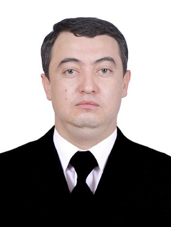
Aziz Nizamovich Inamov
Doctor of Philosophy (PhD) in Technical Sciences, Associate Professor
Aziz Inamov graduated from the Tashkent Institute of Irrigation and Reclamation in 2015 with a master's degree in “Geodesy and Cartography”. In 2013-2014, he was the chief specialist of the National Center for Geodesy and Cartography (0.5 rate), in 2015-2016, a trainee teacher of the “Geodesy and Land Cadastre” department of the Tashkent Institute of Irrigation and Reclamation, in 2016-2017, a trainee teacher of the “Geodesy and Geoinformatics” department of the Tashkent Institute of Irrigation and Reclamation, in 2017-2018, an assistant of the “Geodesy and Geoinformatics” department of the Tashkent Institute of Irrigation and Reclamation, and in 2018, he won the Republican stage in the “Best Educator” nomination and received the academic title of associate professor. In 2021, on 06.01.10, he received the degree of Doctor of Philosophy in Technical Sciences in the specialty “Land Management, Cadastre and Land Monitoring”. In 2018-2024, he was an associate professor at the Department of “Geodesy and Geoinformatics” of the NRU“TIIAME”, and since February 16, 2024, he has been working as the Dean of the Faculty of Land Resources and Cadastre..

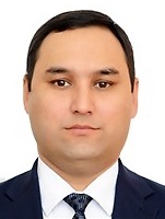
Abduraxmonov Sarvar
In 2005, Sarvar Abdurakhmanov graduated from Tashkent Institute of Architecture and Construction, majoring in "Applied Geodesy". In 2005-2017, he worked as an assistant, senior teacher of the Department of "Geodesy and Land Cadastre" of the Tashkent Institute of Irrigation and Reclamation, and in 2011-2018, he worked as a deputy dean. In 2019, he successfully defended his thesis and received the degree of Doctor of Philosophy (PhD) in technical sciences, in 2021 he received the degree of the title of associate professor in the specialty “Geodesy. Cartography”. Since 2021, he has been working as an associate professor of the “Geodesy and Geoinformatics” department and deputy dean of the “Land Resources and Cadastre” faculty of the Tashkent Institute of Irrigation and Agricultural Mechanization Engineers.
Khikmatullaev Sanjar Izzatullayevich
In 2014, he graduated from the Tashkent Institute of irrigation and melioration with a degree in “Geodesy and cartography”. He served as assistant of the Department of “Geodesy and Geoinformatics” of the Tashkent Institute of irrigation and agricultural mechanization engineers from 2016-2019. In 2023, he successfully defended his dissertation work and received the degree of Doctor of Philosophy (PhD) in technical sciences. He has been working as a senior lecturer at the Department of Geodesy and Geoinformatics of the National Research University “Tashkent Institute of irrigation and agricultural mechanization engineers” since 2023, deputy dean for youth work of the Faculty of “land resources and cadastre” since September 2024. Sanjar Khikmatullayev conducts scientific research in Geodesy, cartography, Geoinformatics, Cadastral areas.
60112400 - Professional training (Land cadastre and land surveying)
60112400 - Professional education (Land cadastre and land surveying) bachelor's education course is used in various sectors of the economy by effectively organizing the educational process, conducting pedagogical and production activities in secondary special and vocational educational institutions land resources, their distribution by categories of the land fund, control over their use and condition, allocation of real estate objects, including land plots on the border of cities and settlements, establishment of agricultural production areas, control over land use making and monitoring; land information systems; prepares highly educated specialists engaged in the field of professional education in the preparation of personnel with secondary special education in the preparation of project-technical documents for land development.
60722700-Innovative technologies in remote sensing of the Earth
60722700-Innovative technologies in remote sensing of the Earth - a direction in the field of science and technology, in determining the shape and size of the Earth and planets, in determining the resources on the surface and in the depths of the Earth based on carrying out special measurements in the remote sensing of the Earth, construction the use of remote sensing methods in the construction and use of objects, in the preparation of maps and plans in our country, and in the establishment of cartographic and geo-information systems, remote sensing in scientific and practical purposes as a model of the earth, covering a complex set of issues related to the methods and methods of human activity takes
60722800-Cadastre (by types of activity)
60722800-Cadastre (by types of activity) educational direction education is a direction related to the field of cadastre, objects used in various sectors of the economy, state cadastres maintained in the republic, infrastructure and use of the Cadastre Agency, cadastral land plots and security objects on them, shipping from place, ownership of places, legal status of transportation of goods from objects, quantity and quality indicators, then with a higher education in control and management of cargo transportation prepares specialists.
60810600 - "Land Cadastre and Land Survey"
60810600 - "Land cadastre and land structure" - undergraduate education course, land resources used in various sectors of the economy, their distribution by land fund categories, land use and land ownership, legal status, quantity and quality description of land use, control and management of the use and condition of real estate objects, including allotment of land plots on the border of cities and settlements, determination of their legal status, the establishment of agricultural production area, control, and monitoring of land use; land information systems; prepares highly educated specialists in preparation of project-technical documents for land development.
60722600 - "Geodesy and geoinformatics"
60722600 - "Geodesy and geoinformatics" - objects of the bachelor's professional activity in the field of undergraduate education: the surfaces of the Earth and planets, artificial and natural objects in the earth and planets, including their use and control and management and carrying out geodesy, cartography and cadastral work in controlling the use of real estate objects, including land plots within the borders of cities and residential areas; the use of geodesy, cartography and cadastral data in the maintenance of the geoinformation system, the use of project technical documents and technical service.
7810601-Usage and management of land resources
7810601-Usage and management of land resources - master's course of study to the objects of the master's professional activity: land resources used in various sectors of the national economy, their distribution by land fund categories, land use and land ownership, land use legal status, quantity and quality description, control and management of their use and status, as well as real estate objects, including land plots on the borders of cities and settlements, their legal status, state registration, assessment, control its use; cadastral information systems; project technical documents. keeps track of all documents in the area
70722601- Geodesy and Geoinformatics
70722601- Geodesy and Geoinformatics - objects of professional activity in the field of master's education: the surfaces of the Earth and planets, artificial and natural objects in the depths of the Earth and planets, including the control and management of their use and condition, and carrying out geodesy, cartography and cadastral work in controlling the use of real estate objects, including land plots on the border of cities and residential areas; the use of geodesy, cartography and cadastral data in the maintenance of the geo-information system, the use of project technical documents and technical support. Strengthening the material and technical base, as well as organizing educational and production practices
Other information
Web-site: https://tiiame.uz/faculties/faculties?id=5
Dean of faculty: Aziz Nizamovich Inamov
Reception days: Wednesday: 10: 00-13: 00